1970s
1974
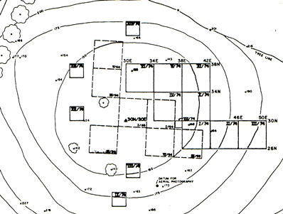
In the 60's, Basler had opened series of adjacent, 4m by 4m units oriented North. All traces of these excavations had disappeared at the start of the 1974/76 project and a new grid was set using an aerial photography benchmark recorded on topographic maps was used to measure elevations (Z) . The approximate center of Basler's excavation was 30m North and 30 m East of the marker used as the datum point. The eight unit block opened in 1974 was to the east of Basler's old trenches (KIEast). Four additional 2m by 2m test pits showed that clusters of artifacts continued to the west but that the archaeological layer disappeared to the south. The first three units (I, II, and III) contained little or no material in place. However, fragments of backed bladelets recovered in the plow zone identified the site as Late Paleolithic. Artifacts were abundant in the loam level (Level 2) of units IV, V, VII, X, and XI where they formed a well defined archaeological layer.
1976
When excavations resumed in 1976, four new units were opened in the area to the west of Basler's trenches where test pits had given positive results. (KIWest). Remnants of a hearth, including burned bone fragments and heat cracked stones, were recovered at the center of sector IWest. Large pieces of sandstones surrounded by fragments of ground hematite and chunks of ocher found at the center of artifact clusters marked an activity area, perhaps used for hide working.
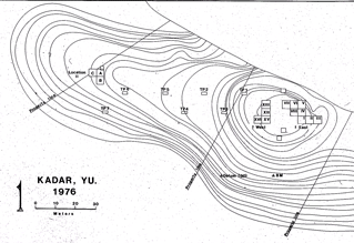
Test pits set 20m apart along the hilltop showed that thin scatters of artifacts covered the whole area to the West of the original site, between the excavations and the edge of the bluff As a result, a new section of three 4m by 4m units (A, B, and C), designated Kadar II, was opened in an area marked by more heavy artifact concentrations (KII). There the upper loam level contained two superimposed archaeological layers which could be identified most clearly in Unit B (see illustration below).
In all areas, the original placement of artifacts had been somewhat disturbed by rain water and other natural phenomena. But displacement were limited and artifact clusters retained some of their original organization. The relative abundance of artifacts recovered in the plow zone of the IEast and IWest sectors suggests that plowing destroyed, or at least disturbed, the uppermost archaeological deposits in these two sectors.