Introduction
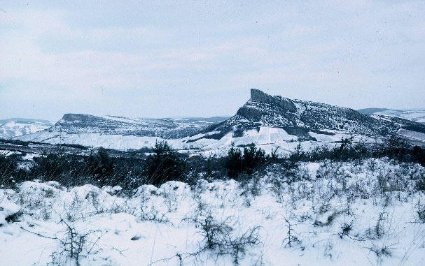
The Paleolithic site of Solutré and the escarpment which protects it from the northwest winds are located a few miles west of the modern city of Mâcon, at the southern Gate of Burgundy where roads (and probably prehistoric trails as well) from the Paris Basin to the north, Belgium to the north-east, and Germany to the east, converge before entering the Saône-Rhône corridor toward the Mediterranean.
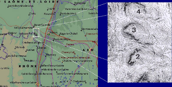
Five cuestas of Jurassic limestone separate the granitic uplands of the Monts du Mâconnais to the west from the alluvial plain of the Saône River to the east. They are from north to south, Monsard, Montagne de St.-Claude (4), Roche de Vergisson (3), Roche de Solutré (2) and Mont Pouilly (1). The small valleys separating the cuestas form natural roads between plain and plateau.
Protected from the dominant northern and western winds, the main site known as Le Cros du Charnier covers an area of more than one hectare, on the south-east side of the Roc. But, Paleolithic remains extend well beyond the limits of the main site. Artifacts were found within and around the modern village and the vineyards of Solutré-Pouilly immediately below the
Cros.
In prehistoric times, it is likely that game herds followed the ravine that separates the Roche of Solutré from the Mont Pouilly in their seasonal migrations between the alluvial Plain and the Uplands. The arched shape of the southern flank of the Roche would then have formed a natural trap where Paleolithic hunters could capture their prey.